
 Samiksha Bharti News Service
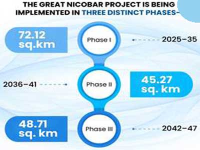
The Great Nicobar Project is a strategic initiative aimed at strengthening India’s presence in the Andaman Sea and Southeast Asia. The project seeks to balance port-led growth with calibrated environmental safeguards and protection of indigenous communities. By combining strategic, economic, and ecological priorities, the project seeks to ensure that development in Great Nicobar is sustainable, inclusive, and aligned with national interests.
The project includes an International Container Transhipment Terminal with a capacity of 14.2 million Twenty-Foot Equivalent Units, a Greenfield International Airport, a 450 Megavolt-Ampere gas- and solar-based power plant, and a new township spanning 16,610 hectares.
Read in Hindi: सामरिक महत्व, सतत विकास का अद्भुत उदाहरण है ग्रेट निकोबार परियोजना
The development follows a sensitive and holistic approach. It considers the needs of indigenous communities and aims to protect the island’s ecological resources. The plan evaluates social, cultural, and environmental impacts carefully and prioritises options that balance environmental, social, and economic goals.
India's ports lack deep-water berths for large ships. Because of this, cargo is routed through Colombo and Singapore. India loses substantial revenue as a result. Countries like Myanmar, China and Sri Lanka are already building deep-water facilities to capture this trade.
In this context, the International Container Transhipment Port at Galathea Bay is being developed as part of the Holistic Development of Great Nicobar Island under the Island Development programme. Along with the proposed airport, township, and power plant, the Galathea Bay transhipment port forms a major infrastructure component of the overall Great Nicobar Project.
The port is strategically important because it is located close to the East-West international shipping route, about 40 nautical miles away, and has a natural water depth of over 20 metres. This strategic location gives it an advantage to attract both gateway and transhipment cargo, reducing India’s dependence on foreign ports like Colombo, Singapore and Klang. The project is designed to enhance India’s national security, strategic and defence presence, strengthen the islands’ economic position, and accelerate holistic development in the region.
The island has world-class ecological resources that can attract international and Indian tourists. An international airport is necessary to improve connectivity and open up the island to tourism. The island is close to international tourist destinations like Senang City, Phuket Island and Langkawi Island. Port Blair airport currently handles approximately 1.8 million passengers annually. The new airport is expected to handle at least one million passengers when it opens and grow to approximately 10 million passengers per year thereafter.
The planned township is intended to support the residential, commercial and institutional requirements arising from the port-led development of the island. It will provide essential urban infrastructure for personnel, service providers and associated economic activities, in line with the overall integrated development framework.
Reliable power infrastructure is essential for the operation of the transhipment terminal, airport and associated urban infrastructure. Currently, diesel generating sets are the major source of energy in the Andaman & Nicobar Islands. The primary objective of the Power Plant is to provide good quality, reliable electrical energy without interruptions. The system is designed to ensure continuity of power supply even if one primary component fails. Renewable energy sources will also be planned for additional generation. An uninterrupted energy supply is a key component in increasing the GDP of the island.
The Great Nicobar Project is being implemented in three distinct phases, including Phase I (2025–35, 72.12 sq. km), Phase II (2036–41, 45.27 sq. km), and Phase III (2042–47, 48.71 sq. km)
It covers a total area of 166.10 sq km, which includes 35.35 sq km of revenue land and 130.75 sq km of forest land. This phased approach allows for systematic infrastructure development while ensuring that environmental safeguards and tribal welfare measures are effectively integrated at each stage.
The project’s strategic and economic significance is underscored by the need to position Great Nicobar as a critical node in the Indian Ocean Region. The project ensures optimised land use, coordinated ecological management, and long-term regional benefits, while remaining fully compliant with Environmental Impact Assessment regulations and statutory approvals.
Environmental Impact Assessment is a tool to ensure proper use of natural resources for sustainable development. EIA is mandatory for specified categories of projects, as per the schedule of Environmental Impact Assessment Notification, 2006. Expert Committees for different sectors examine project proposals, assess environmental impacts, and recommend approval or rejection.
The project received prior Environmental Clearance under the EIA Notification, 2006, after a detailed process of screening, scoping, public consultation and appraisal.
The Great Nicobar Project will divert 1.82 per cent of the total forest cover of the Andaman and Nicobar Islands. The estimated number of trees in this area is 18.65 lakh, though the maximum number expected to be felled is 7.11 lakh within 49.86 sq km of forest. The tree felling will be carried out in a phased manner in line with the proposed phase-wise development of the key projects.
Importantly, 65.99 sq km of land will be preserved as green zones with no tree felling, ensuring ecological balance. Since the islands already have over 75 per cent forest cover, compensatory afforestation cannot be carried out locally. Instead, afforestation is planned in Haryana, with 97.30 sq km of land identified to compensate for the Phase I diversion of 48.65 sq km of forest. Additionally, under ‘Ek Ped Maa Ke Naam’, 2.4 million trees have been planted in the Andaman and Nicobar Islands.
The Great Nicobar Island is inhabited by the aboriginal Mongoloid tribes, the Shompens, who are hunter-gatherers, and the Nicobarese, who live in coastal settlements and depend mainly on fishing for survival. The Great Nicobar Project has been carefully designed to ensure that the Nicobarese and Shompen tribes are not displaced. Within the project area, the only tribal habitations are located at New Chingen and Rajiv Nagar, and the administration has explicitly stated that no relocation of tribal communities is proposed.
The Great Nicobar Project is fully aligned with the Shompen Policy of 2015 and the Jarawa Policy of 2004, which mandate that large-scale development proposals prioritise the welfare and integrity of Particularly Vulnerable Tribal Groups and follow a structured consultation process.
To safeguard tribal interests, an Independent monitoring committee has been mandated by the Ministry of Environment, Forest and Climate Change to oversee issues affecting the Shompen and Nicobarese during both construction and operation phases. Consultations have also been conducted with the Ministry of Tribal Affairs, the Directorate of Tribal Welfare, the Andaman Adim Janjati Vikas Samiti, and tribal experts, including the Anthropological Survey of India, to ensure the safety, protection and well-being of the communities.
The project implementation framework is aligned with the provisions of Article 338A (9) of the Constitution, with due emphasis on safeguarding the interests of Scheduled Tribes and Particularly Vulnerable Tribal Groups in the region. Importantly, the Union Territory of the Andaman and Nicobar Islands has undertaken no new policy measures affecting these tribes beyond implementing this development project, ensuring that tribal rights and welfare remain central to the planning process.
Currently, Great Nicobar Island has 751.070 sq km of land officially marked as a Tribal Reserve. Out of the 166.10 sq km that is proposed for development projects, 84.10 sq km overlaps with the Tribal Reserve. However, within this portion, 11.032 sq km has already been settled and used as revenue land since 1972. Consequently, the effectively remaining area measuring 73.07 sq km is being de-notified for project purposes.
To compensate, 76.98 sq km is being re-notified as a tribal reserve, resulting in a net addition of 3.912 sq km to the tribal reserve. Specifically, in Phase I, only 40.01 sq km of tribal area is involved in the project, with 11.032 sq km already under revenue use since 1972.
The island lies in a seismically sensitive and cyclone-prone region. To address this, a comprehensive risk assessment study has been conducted covering both natural disasters and anthropogenic risks. A vulnerability and disaster management plan has been prepared, ensuring preparedness for emergencies. Moreover, the reliance on a hybrid power plant ensures resilience against disruptions while reducing carbon emissions.
Overall, the Great Nicobar Project is an example of how holistic development can balance economic growth, ecological conservation, and social inclusion. It leverages Great Nicobar’s strategic location to strengthen India’s national security, maritime and defence presence in the Indo-Pacific, while simultaneously embedding strong environmental safeguards and tribal welfare mechanisms. By committing to wildlife conservation, compensatory afforestation, disaster preparedness, and social inclusion, the government demonstrates that development need not come at the expense of the environment.
Ultimately, the project represents a model for future large-scale infrastructure initiatives in ecologically sensitive regions, showing how economy and ecology, rather than being at odds, can reinforce one another to serve national and global interests.


Related Items
Every fifth Indian will be elderly; is India ready…!
India's first hydrogen fuel cell train redefines sustainable rail mobility
Rakesh Bedi to host ‘Two Great Masters’