
Cut back to year December 26, 2004, the day world's one of the most devastating disaster struck killing 2,30,000 people in 14 countries along the rim of the Indian Ocean. Massive waves swept away buildings and people as if they were just pieces of paper. The damage was worst in Indonesia, Thailand, India and Sri Lanka. In India, an estimated 10,749 persons lost their life and 5,640 people were reported missing.
The disaster led to much soul searching as it soon became clear that much of the casualty could have been avoided if only there had been an early warning system for tsunamis in the Indian Ocean region. There were two tsunami warning centres at the global level. But, they catered to the pacific region only. Nobody expected a tsunami in the Indian Ocean.
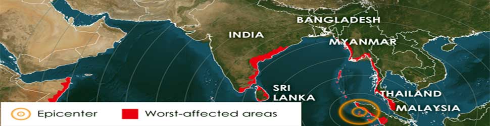
The Tsunami was generated by an undersea earthquake about 250 km south west of the Indonesian city of Banda Aceh and it took anywhere between 15 minutes to seven hours for the fatal waves to reach the various coastlines.
The northern regions of the Indonesian island of Sumatra were hit very quickly. But, east coast of India was affected two hours later and west coast in four hours.
In other words, there was enough time to warn the people in India. Seismologists knew that a massive earthquake with a magnitude of 9.3 on the Richter scale had occurred. But, it was not known that it had generated a tsunami.
As a result, huge tsunami waves swept India, Sri Lanka, Indonesia, Thailand and other countries along the Indian Ocean with no warning what so ever. In India, the coastal communities in Tamil Nadu, Puducherry, Andhra Pradesh, Kerala, and Andaman and Nicobar Islands were devastated.
Sea change in 12 years
Since then, the situation has undergone a sea change. Today, a 24X7 early warning system is operational. It has a capability to issue tsunami bulletins in less than 10 minutes after any major earthquake in the Indian Ocean. This provides a response / lead time of about 10 to 20 minutes to regions nearer to the epicentre of the quake and a few hours in the case of regions further away.
The great Indian Ocean tsunami occurred on December 26, 2004 and within a year the Government approved the setting up of an early warning system after detailed brainstorming sessions with experts in the field both within and outside the country. Set up at a cost of ₹150 crore, the system became operational on October 15, 2007. Initially, it had a capability to issue a warning within 20 minutes. It has since then been fine tuned and first warning is now available within 10 minutes.
The Indian Tsunami Early Warning System [ITEWS] comprises of a real time network of seismic stations, tsunami buoys and tide gauges. These are linked to a state-of-art tsunami centre – Indian Tsunami Early Warning Centre [ITEWC], where the data are analysed using high power computational systems. Advisories are issued automatically to the various stakeholders beginning from the Ministry of Home Affairs and the National Disaster Management Authority to State and district level disaster management centres for necessary follow up action.
The ITEWC is located at the Union Ministry of Earth Science's Indian National Centre for Ocean Information Services [INCOIS] in Hyderabad.
The real time seismic monitoring network comprises of 17 broadband seismic field stations transmitting real time data through V-SAT communication to the central receiving stations located at INCOIS and the National Centre for Seismology at New Delhi simultaneously for processing and interpretation. In addition, data from around 300 global seismic stations is received at INCOIS in near real time. These data sets form the basis for determining the preliminary parameters of earthquake epicentre, focal depth and magnitude. The earthquakes are auto-located within 5-10 minutes of occurrence.
The brain of the early warning system is a state of the art decision support system at ITEWC, which has a database of all possible earthquake scenarios for the Indian Ocean.
The moment a tsunamigenic earthquake -- an undersea quake with a magnitude of 6.5 and above occurs, the decision support system gets activated and rapidly goes through the database and fishes out the matching advisory.
However, as historical studies have shown clearly, not all underwater earthquakes generate tsunami. There is a need to measure changes in water level in the open ocean with a high level of accuracy in real time to confirm whether a tsunami has actually been triggered. For this, there is need for what are called tsunami buoys.
The ITEWS has a network of seven tsunami buoy systems equipped with the bottom pressure recorders that transmit real time data through satellite communication to INCOIS 24X7. The buoys are strategically placed at locations where a tsunami wave can reach in less than 30 minutes in case an earthquake occurs anywhere in Andaman-Sumatra and Makran Subduction zones.
In addition, INCOIS has established a real time network of 31 tide gauge stations along the Indian coast and receives data from 300 international real time tide gauge stations across the world. The tide gauges supplement the work of the tsunami buoys.
Generally located at the land-sea interface, tide gauges are the ones that physically detect the tsunami waves. Though they provide little advance warning to the place where they are located, they are of great importance as they provide coastal areas where the waves have not yet reached an indication of its speed and strength.
The ITEWS has a unique Standard Operating Procedure (SOP. The criteria for generation of tsunami advisories (warning/alerts/watch) for a particular region of the coast are based on the available warning time. The Indian warning criteria are based on the premise that coastal areas falling within 60 minutes travel time from a tsunamigenic earthquake source need to be warned based solely on earthquake information, since enough time will not be available for confirmation of water levels from the tsunami buoys and the tide gauges. Coastal areas falling outside the 60 minute travel time can be initially placed under a watch status and upgraded to a warning or given an all-clear message depending on the water level data.
The tsunami warning centre disseminates the advisories to the various stakeholders through multiple modes simultaneously such as email, fax, phone, GTS and SMS. The earthquake information, tsunami bulletins as well as the real time sea level observations are also made available on INCOIS website for officials, public and media.
The centre serves not only as a national facility but also as a regional tsunami advisory service provider responsible for providing tsunami advisories to all the countries in the Indian Ocean region. This responsibility was formally handed over to it by UNESCO on October 12, 2011.
ITEWC has been organizing national & international workshops, trainings and seminars to create awareness about tsunamis in general public, school children and disaster management community. To test the communications links with disaster management authorities, the centre conducts Communications test every 6 months.
ITEWC regularly conducts tsunami mock drills to test the efficiency of communication links and evaluate the readiness of the disaster management system and the local community to handle emergency situations. The latest tsunami mock drill IOWave16 was conducted on September 7-8, 2016. For the first time, around 40,000 people participated from about 350 villages from 33 Coastal Districts of 8 States/UTs.
In line with consistent improvements to the tsunami warning services, ITEWC is currently establishing a network of 35 strong motion accelerometers and GNSS receivers at Andaman & Nicobar Islands. The major objective of the exercise is to improve the capability to characterise the rupture direction and area as to enable quicker estimation of the tsunamigenenic potential of an earthquake. In addition to this, a national network of near real time seismic and GNSS stations has been established.
The new geospatial technologies such as 3D GIS has transformed the way in which coasts can be mapped and managed, which in turn can be used for improving the accuracies of coastal inundation modelling.
INCOIS has, among other things, initiated preliminary work on cutting edge research areas such as: (i) Multi-hazard Vulnerability Mapping, (iii) Real-time tsunami inundation modelling as well as (iii) 3-D GIS. The broad scientific methodologies have been established and pilot work has been successfully completed for a few areas.
(Author is Director, ESSO-Indian National Centre for Ocean Information Services. The views expressed in the Article are author’s own.)


Related Items
When IndiGo’s engines died, the whole rotten system crashed…
Police system trapped in swamp of blood, bribery, and injustice!
Guess! Which body part did early humans cover first, and why?